
Cartographer or Photogrammetrist
Does this career fit your work personality?
Begin The Career Assessment Test- Best Fitting Careers
- Work Personality Strengths
- Work Style Preferences
- and more
Job Outlook
Employment of cartographers and photogrammetrists is projected to grow 5 percent from 2022 to 2032, faster than the average for all occupations.
About 1,000 openings for cartographers and photogrammetrists are projected each year, on average, over the decade. Many of those openings are expected to result from the need to replace workers who transfer to different occupations or exit the labor force, such as to retire.
Education Details
Summary of What they do:
Research, study, and prepare maps and other spatial data in digital or graphic form for one or more purposes, such as legal, social, political, educational, and design purposes. May work with Geographic Information Systems (GIS). May design and evaluate algorithms, data structures, and user interfaces for GIS and mapping systems. May collect, analyze, and interpret geographic information provided by geodetic surveys, aerial photographs, and satellite data.
What Cartographers and Photogrammetrists Do
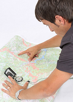
Cartographers and photogrammetrists collect, measure, and interpret geographic information in order to create and update maps and charts for regional planning, education, and other purposes.
Duties
Cartographers typically do the following:
- Collect geographic data
- Create visual representations of data, such as annual precipitation patterns
- Examine and compile data from ground surveys, reports, aerial photographs, and satellite images
- Prepare maps in digital or graphic form for environmental and educational purposes
- Update and revise existing maps and charts
Photogrammetrists typically do the following:
- Plan aerial and satellite surveys to ensure complete coverage of the area in question
- Collect and analyze spatial data, such as elevation and distance
- Develop base maps that allow Geographic Information System (GIS) data to be layered on top
Cartographers are mapmakers who design user-friendly maps. Photogrammetrists are specialized mapmakers who use various technologies to build models of the Earth’s surface and its features for the purpose of creating maps.
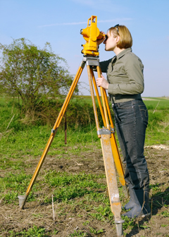
Cartographers and photogrammetrists use information from geodetic surveys (land surveys that account for the curvature of the Earth’s surface) and remote-sensing systems, including aerial cameras and satellites. Some also use light-imaging detection and ranging (LIDAR) technology. LIDAR systems use lasers attached to planes or cars to digitally map the topography of the Earth. Because LIDAR is often more accurate than traditional surveying methods, it can also be used to collect other forms of data, such as the location and density of forests.
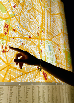
Cartographers and photogrammetrists often develop online and mobile maps. Interactive maps are popular, and cartographers and photogrammetrists collect data and design these maps for mobile phones and navigation systems.
Cartographers and photogrammetrists also create maps and perform aerial surveys for governments, to aid in urban and regional planning. Such maps may include information on population density and demographic characteristics. Some cartographers and photogrammetrists help build maps for government agencies for work involving national security and public safety. Accurate maps help emergency responders provide assistance as quickly as possible.
Cartographers and photogrammetrists who use GIS technology to create maps are often known as geographic information specialists. GIS technology is typically used to assemble, integrate, analyze, and present spatial information in a digital format. Maps created with GIS technology combine spatial graphic features with data. These maps are used to provide support for decisions involving environmental studies, geology, engineering, land-use planning, and business marketing.
Important Qualities
Computer skills. Both cartographers and photogrammetrists must have experience working with computer data and coding. Maps are created digitally, so knowing how to edit them on a computer is essential.
Critical-thinking skills. Cartographers may work from existing maps, surveys, and other records, and they must be able to determine the accuracy of each feature being mapped.
Decision-making skills. Both cartographers and photogrammetrists must make decisions about the accuracy and readability of a map. They must decide what information they require in order to meet the client’s needs.
Detail oriented. Cartographers must focus on details when conceiving a map and deciding what features to include. Photogrammetrists must pay close attention to detail when interpreting aerial photographs and remotely sensed data.
Problem-solving skills. Cartographers and photogrammetrists must be able to reconcile differences between aerial photographs, land surveys, and satellite images.
Tasks On The Job
- Build and update digital databases.
- Collect information about specific features of the Earth, using aerial photography and other digital remote sensing techniques.
- Compile data required for map preparation, including aerial photographs, survey notes, records, reports, and original maps.
- Delineate aerial photographic detail, such as control points, hydrography, topography, and cultural features, using precision stereoplotting apparatus or drafting instruments.
- Determine guidelines that specify which source material is acceptable for use.
- Determine map content and layout, as well as production specifications such as scale, size, projection, and colors, and direct production to ensure that specifications are followed.
- Examine and analyze data from ground surveys, reports, aerial photographs, and satellite images to prepare topographic maps, aerial-photograph mosaics, and related charts.
- Identify, scale, and orient geodetic points, elevations, and other planimetric or topographic features, applying standard mathematical formulas.
- Inspect final compositions to ensure completeness and accuracy.
- Prepare and alter trace maps, charts, tables, detailed drawings, and three-dimensional optical models of terrain using stereoscopic plotting and computer graphics equipment.
- Revise existing maps and charts, making all necessary corrections and adjustments.
- Select aerial photographic and remote sensing techniques and plotting equipment needed to meet required standards of accuracy.
- Study legal records to establish boundaries of local, national, and international properties.
- Travel over photographed areas to observe, identify, record, and verify all relevant features.

PERSONALITY
| Your Assessment Results |
CAREER CHARACTERISTICS
Importance
|
|---|
|
?
? ? ?
|
91% | Attention to Detail - Job requires being careful about detail and thorough in completing work tasks. | |
|
?
? ? ?
|
79% | Dependability - Job requires being reliable, responsible, and dependable, and fulfilling obligations. | |
|
?
? ? ?
|
74% | Cooperation - Job requires being pleasant with others on the job and displaying a good-natured, cooperative attitude. | |
|
?
? ? ?
|
71% | Innovation - Job requires creativity and alternative thinking to develop new ideas for and answers to work-related problems. | |
|
?
? ? ?
|
71% | Adaptability/Flexibility - Job requires being open to change (positive or negative) and to considerable variety in the workplace. | |
|
?
? ? ?
|
70% | Initiative - Job requires a willingness to take on responsibilities and challenges. | |
|
?
? ? ?
|
69% | Persistence - Job requires persistence in the face of obstacles. | |
|
?
? ? ?
|
68% | Integrity - Job requires being honest and ethical. | |
|
?
? ? ?
|
66% | Achievement/Effort - Job requires establishing and maintaining personally challenging achievement goals and exerting effort toward mastering tasks. | |
|
?
? ? ?
|
65% | Analytical Thinking - Job requires analyzing information and using logic to address work-related issues and problems. | |
|
?
? ? ?
|
63% | Independence - Job requires developing one's own ways of doing things, guiding oneself with little or no supervision, and depending on oneself to get things done. | |
|
?
? ? ?
|
60% | Leadership - Job requires a willingness to lead, take charge, and offer opinions and direction. | |
|
?
? ? ?
|
57% | Self-Control - Job requires maintaining composure, keeping emotions in check, controlling anger, and avoiding aggressive behavior, even in very difficult situations. | |
|
?
? ? ?
|
52% | Stress Tolerance - Job requires accepting criticism and dealing calmly and effectively with high-stress situations. | |
| Your Assessment Results |
IMPORTANT STRENGTHS
Importance
|
|---|
|
?
? ? ?
|
78% | Realistic - Work involves designing, building, or repairing of equipment, materials, or structures, engaging in physical activity, or working outdoors. Realistic occupations are often associated with engineering, mechanics and electronics, construction, woodworking, transportation, machine operation, agriculture, animal services, physical or manual labor, athletics, or protective services. | |
|
?
? ? ?
|
72% | Investigative - Work involves studying and researching non-living objects, living organisms, disease or other forms of impairment, or human behavior. Investigative occupations are often associated with physical, life, medical, or social sciences, and can be found in the fields of humanities, mathematics/statistics, information technology, or health care service. | |
|
?
? ? ?
|
72% | Conventional - Work involves following procedures and regulations to organize information or data, typically in a business setting. Conventional occupations are often associated with office work, accounting, mathematics/statistics, information technology, finance, or human resources. | |
| Your Assessment Results |
WORK VALUES
Importance
|
|---|
|
?
? ? ?
|
67% | Achievement - Occupations that satisfy this work value are results oriented and allow employees to use their strongest abilities, giving them a feeling of accomplishment. Corresponding needs are Ability Utilization and Achievement. | |
|
?
? ? ?
|
61% | Working Conditions - Occupations that satisfy this work value offer job security and good working conditions. Corresponding needs are Activity, Compensation, Independence, Security, Variety and Working Conditions. | |
|
?
? ? ?
|
61% | Independence - Occupations that satisfy this work value allow employees to work on their own and make decisions. Corresponding needs are Creativity, Responsibility and Autonomy. | |
APTITUDES
| Your Assessment Results |
ABILITIES | SKILLS
Importance
|
|---|
|
?
? ? ?
|
75% | Written Comprehension - The ability to read and understand information and ideas presented in writing. | |
|
?
? ? ?
|
72% | Oral Comprehension - The ability to listen to and understand information and ideas presented through spoken words and sentences. | |
|
?
? ? ?
|
72% | Near Vision - The ability to see details at close range (within a few feet of the observer). | |
|
?
? ? ?
|
66% | Inductive Reasoning - The ability to combine pieces of information to form general rules or conclusions (includes finding a relationship among seemingly unrelated events). | |
|
?
? ? ?
|
63% | Oral Expression - The ability to communicate information and ideas in speaking so others will understand. | |
|
?
? ? ?
|
63% | Written Expression - The ability to communicate information and ideas in writing so others will understand. | |
|
?
? ? ?
|
63% | Deductive Reasoning - The ability to apply general rules to specific problems to produce answers that make sense. | |
|
?
? ? ?
|
60% | Flexibility of Closure - The ability to identify or detect a known pattern (a figure, object, word, or sound) that is hidden in other distracting material. | |
|
?
? ? ?
|
59% | Reading Comprehension - Understanding written sentences and paragraphs in work-related documents. | |
|
?
? ? ?
|
56% | Information Ordering - The ability to arrange things or actions in a certain order or pattern according to a specific rule or set of rules (e.g., patterns of numbers, letters, words, pictures, mathematical operations). | |
|
?
? ? ?
|
56% | Visualization - The ability to imagine how something will look after it is moved around or when its parts are moved or rearranged. | |
|
?
? ? ?
|
56% | Far Vision - The ability to see details at a distance. | |
|
?
? ? ?
|
54% | Critical Thinking - Using logic and reasoning to identify the strengths and weaknesses of alternative solutions, conclusions, or approaches to problems. | |
|
?
? ? ?
|
53% | Problem Sensitivity - The ability to tell when something is wrong or is likely to go wrong. It does not involve solving the problem, only recognizing that there is a problem. | |
|
?
? ? ?
|
53% | Category Flexibility - The ability to generate or use different sets of rules for combining or grouping things in different ways. | |
|
?
? ? ?
|
53% | Speech Recognition - The ability to identify and understand the speech of another person. | |
|
?
? ? ?
|
53% | Speech Clarity - The ability to speak clearly so others can understand you. | |
|
?
? ? ?
|
52% | Writing - Communicating effectively in writing as appropriate for the needs of the audience. | |
| Your Assessment Results |
TASKS | ACTIVITIES
Importance
|
|---|
|
?
? ? ?
|
97% | Getting Information - Observing, receiving, and otherwise obtaining information from all relevant sources. | |
|
?
? ? ?
|
92% | Working with Computers - Using computers and computer systems (including hardware and software) to program, write software, set up functions, enter data, or process information. | |
|
?
? ? ?
|
81% | Evaluating Information to Determine Compliance with Standards - Using relevant information and individual judgment to determine whether events or processes comply with laws, regulations, or standards. | |
|
?
? ? ?
|
81% | Making Decisions and Solving Problems - Analyzing information and evaluating results to choose the best solution and solve problems. | |
|
?
? ? ?
|
80% | Updating and Using Relevant Knowledge - Keeping up-to-date technically and applying new knowledge to your job. | |
|
?
? ? ?
|
80% | Identifying Objects, Actions, and Events - Identifying information by categorizing, estimating, recognizing differences or similarities, and detecting changes in circumstances or events. | |
|
?
? ? ?
|
79% | Documenting/Recording Information - Entering, transcribing, recording, storing, or maintaining information in written or electronic/magnetic form. | |
|
?
? ? ?
|
78% | Processing Information - Compiling, coding, categorizing, calculating, tabulating, auditing, or verifying information or data. | |
|
?
? ? ?
|
78% | Communicating with People Outside the Organization - Communicating with people outside the organization, representing the organization to customers, the public, government, and other external sources. This information can be exchanged in person, in writing, or by telephone or e-mail. | |
|
?
? ? ?
|
77% | Analyzing Data or Information - Identifying the underlying principles, reasons, or facts of information by breaking down information or data into separate parts. | |
|
?
? ? ?
|
77% | Communicating with Supervisors, Peers, or Subordinates - Providing information to supervisors, co-workers, and subordinates by telephone, in written form, e-mail, or in person. | |
|
?
? ? ?
|
72% | Thinking Creatively - Developing, designing, or creating new applications, ideas, relationships, systems, or products, including artistic contributions. | |
|
?
? ? ?
|
71% | Establishing and Maintaining Interpersonal Relationships - Developing constructive and cooperative working relationships with others, and maintaining them over time. | |
|
?
? ? ?
|
70% | Scheduling Work and Activities - Scheduling events, programs, and activities, as well as the work of others. | |
|
?
? ? ?
|
70% | Estimating the Quantifiable Characteristics of Products, Events, or Information - Estimating sizes, distances, and quantities; or determining time, costs, resources, or materials needed to perform a work activity. | |
|
?
? ? ?
|
69% | Organizing, Planning, and Prioritizing Work - Developing specific goals and plans to prioritize, organize, and accomplish your work. | |
|
?
? ? ?
|
68% | Monitoring Processes, Materials, or Surroundings - Monitoring and reviewing information from materials, events, or the environment, to detect or assess problems. | |
|
?
? ? ?
|
63% | Performing for or Working Directly with the Public - Performing for people or dealing directly with the public. This includes serving customers in restaurants and stores, and receiving clients or guests. | |
|
?
? ? ?
|
63% | Interpreting the Meaning of Information for Others - Translating or explaining what information means and how it can be used. | |
|
?
? ? ?
|
60% | Coordinating the Work and Activities of Others - Getting members of a group to work together to accomplish tasks. | |
|
?
? ? ?
|
60% | Developing Objectives and Strategies - Establishing long-range objectives and specifying the strategies and actions to achieve them. | |
|
?
? ? ?
|
58% | Drafting, Laying Out, and Specifying Technical Devices, Parts, and Equipment - Providing documentation, detailed instructions, drawings, or specifications to tell others about how devices, parts, equipment, or structures are to be fabricated, constructed, assembled, modified, maintained, or used. | |
|
?
? ? ?
|
56% | Training and Teaching Others - Identifying the educational needs of others, developing formal educational or training programs or classes, and teaching or instructing others. | |
|
?
? ? ?
|
56% | Resolving Conflicts and Negotiating with Others - Handling complaints, settling disputes, and resolving grievances and conflicts, or otherwise negotiating with others. | |
|
?
? ? ?
|
55% | Developing and Building Teams - Encouraging and building mutual trust, respect, and cooperation among team members. | |
|
?
? ? ?
|
51% | Judging the Qualities of Objects, Services, or People - Assessing the value, importance, or quality of things or people. | |
| Your Assessment Results |
CONTEXT | ATTRIBUTES
Importance
|
|---|
|
?
? ? ?
|
99% | Indoors, Environmentally Controlled - How often does this job require working indoors in environmentally controlled conditions? | |
|
?
? ? ?
|
97% | Electronic Mail - How often do you use electronic mail in this job? | |
|
?
? ? ?
|
97% | Importance of Being Exact or Accurate - How important is being very exact or highly accurate in performing this job? | |
|
?
? ? ?
|
96% | Spend Time Sitting - How much does this job require sitting? | |
|
?
? ? ?
|
92% | Telephone - How often do you have telephone conversations in this job? | |
|
?
? ? ?
|
90% | Face-to-Face Discussions - How often do you have to have face-to-face discussions with individuals or teams in this job? | |
|
?
? ? ?
|
86% | Work With Work Group or Team - How important is it to work with others in a group or team in this job? | |
|
?
? ? ?
|
81% | Deal With External Customers - How important is it to work with external customers or the public in this job? | |
|
?
? ? ?
|
80% | Contact With Others - How much does this job require the worker to be in contact with others (face-to-face, by telephone, or otherwise) in order to perform it? | |
|
?
? ? ?
|
78% | Spend Time Using Your Hands to Handle, Control, or Feel Objects, Tools, or Controls - How much does this job require using your hands to handle, control, or feel objects, tools or controls? | |
|
?
? ? ?
|
77% | Freedom to Make Decisions - How much decision making freedom, without supervision, does the job offer? | |
|
?
? ? ?
|
77% | Coordinate or Lead Others - How important is it to coordinate or lead others in accomplishing work activities in this job? | |
|
?
? ? ?
|
74% | Time Pressure - How often does this job require the worker to meet strict deadlines? | |
|
?
? ? ?
|
74% | Structured versus Unstructured Work - To what extent is this job structured for the worker, rather than allowing the worker to determine tasks, priorities, and goals? | |
|
?
? ? ?
|
69% | Impact of Decisions on Co-workers or Company Results - What results do your decisions usually have on other people or the image or reputation or financial resources of your employer? | |
|
?
? ? ?
|
63% | Importance of Repeating Same Tasks - How important is repeating the same physical activities (e.g., key entry) or mental activities (e.g., checking entries in a ledger) over and over, without stopping, to performing this job? | |
|
?
? ? ?
|
63% | Spend Time Making Repetitive Motions - How much does this job require making repetitive motions? | |
|
?
? ? ?
|
59% | Frequency of Decision Making - How frequently is the worker required to make decisions that affect other people, the financial resources, and/or the image and reputation of the organization? | |
|
?
? ? ?
|
55% | Letters and Memos - How often does the job require written letters and memos? | |
|
?
? ? ?
|
54% | Physical Proximity - To what extent does this job require the worker to perform job tasks in close physical proximity to other people? | |
|
?
? ? ?
|
54% | Responsibility for Outcomes and Results - How responsible is the worker for work outcomes and results of other workers? | |
|
?
? ? ?
|
52% | Sounds, Noise Levels Are Distracting or Uncomfortable - How often does this job require working exposed to sounds and noise levels that are distracting or uncomfortable? | |
|
?
? ? ?
|
66% | Duration of Typical Work Week - Number of hours typically worked in one week. | |
Work Environment
Cartographers and photogrammetrists held about 14,000 jobs in 2022. The largest employers of cartographers and photogrammetrists were as follows:
| Local government, excluding education and hospitals | 33% |
| Architectural, engineering, and related services | 20 |
| Management, scientific, and technical consulting services | 7 |
| Federal government | 4 |
| State government, excluding education and hospitals | 4 |
Although cartographers and photogrammetrists spend much of their time in offices, certain jobs require extensive fieldwork to collect data and verify results. For example, cartographers may travel to the physical locations they are mapping to better understand the topography of the region. Similarly, photogrammetrists may conduct fieldwork to plan for aerial surveys and to validate interpretations.
Work Schedules
Most cartographers and photogrammetrists work full time. They may have longer workdays during fieldwork.
Getting Started
How to Become a Cartographer or Photogrammetrist
Cartographers and photogrammetrists typically need a bachelor’s degree in cartography, geography, geomatics, or surveying. Some states require cartographers and photogrammetrists to be licensed as surveyors, and some states have specific licenses for photogrammetrists.
Education
Cartographers and photogrammetrists typically need a bachelor’s degree in cartography, geography, geomatics, or surveying. (Geomatics combines a variety of disciplines, such as engineering, natural resources, and mathematics.)
The growing use of Geographic Information System (GIS) technology has resulted in cartographers and photogrammetrists requiring more courses in computer programming, engineering, math, GIS technology, surveying, and geography.
Cartographers must also be familiar with Web-based mapping technologies, including newer modes of compiling data that incorporate the positioning capabilities of mobile phones and in-car navigation systems.
Photogrammetrists must be familiar with remote sensing, image processing, and light-imaging detection and ranging (LIDAR) technology, and they must be knowledgeable about using the software that is necessary with these tools.
Many aspiring cartographers and photogrammetrists benefit from internships while in school.
Licenses, Certifications, and Registrations
Licensing requirements for cartographers and photogrammetrists vary by state. Some states require cartographers and photogrammetrists to be licensed as surveyors, and some states have specific licenses for photogrammetry and remote sensing. Although licensing requirements vary by state, candidates must meet educational requirements and pass a test.
Cartographers and photogrammetrists may also receive certification from the American Society for Photogrammetry and Remote Sensing (ASPRS). The United States Geospatial Intelligence Foundation offers certifications for GIS professionals. Candidates must meet experience and education requirements and must pass an exam. Although certifications are not required, they can demonstrate competence and may help candidates get a job.
Contacts for More Information
For more information about cartographers and photogrammetrists, visit
Cartography and Geographic Information Society
For more information about photogrammetrists, photogrammetric technicians, remote-sensing scientists, image-based cartographers, or GIS specialists’ careers, visit
American Society for Photogrammetry and Remote Sensing
For information about careers in remote sensing, photogrammetry, surveying, GIS analysis, and other geography-related disciplines, visit
Association of American Geographers
For information related to GIS certification, visit
Similar Occupations
This table shows a list of occupations with job duties that are similar to those of cartographers and photogrammetrists.
| Occupation | Job Duties | Entry-Level Education | Median Annual Pay, May 2022 | |
|---|---|---|---|---|

|
Civil Engineers |
Civil engineers plan, design, and supervise the construction and maintenance of building and infrastructure projects. |
Bachelor's degree | $89,940 |

|
Environmental Scientists and Specialists |
Environmental scientists and specialists use their knowledge of the natural sciences to protect the environment and human health. |
Bachelor's degree | $76,480 |

|
Geographers |
Geographers study the Earth and the distribution of its land, features, and inhabitants. |
Bachelor's degree | $88,900 |

|
Forest and Conservation Workers |
Forest and conservation workers perform physical labor to improve the quality of natural areas such as forests, rangelands, and wetlands. |
High school diploma or equivalent | $32,270 |

|
Landscape Architects |
Landscape architects design parks and other outdoor spaces. |
Bachelor's degree | $73,210 |

|
Surveying and Mapping Technicians |
Surveying and mapping technicians collect data and make maps of the Earth's surface. |
High school diploma or equivalent | $47,180 |
|
|
Surveyors |
Surveyors make precise measurements to determine property boundaries. |
Bachelor's degree | $63,080 |

|
Urban and Regional Planners |
Urban and regional planners develop land use plans and programs that help create communities, accommodate population growth, and revitalize physical facilities. |
Master's degree | $79,540 |

|
Geological and Hydrologic Technicians |
Geological and hydrologic technicians support scientists and engineers in exploring, extracting, and monitoring natural resources. |
Associate's degree | $49,590 |